MAKE A MEME
View Large Image
| View Original: | 1747_La_Feuille_Map_of_Alsace,_France_-_Geographicus_-_Rhyn-lafeuille-1747.jpg (2500x1680) | |||
| Download: | Original | Medium | Small | Thumb |
| Courtesy of: | commons.wikimedia.org | More Like This | ||
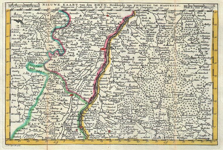
| Keywords: 1747 La Feuille Map of Alsace, France - Geographicus - Rhyn-lafeuille-1747.jpg A stunning map of Alcase France drawn by J Ratelband in 1735 Includes both Basse Alsace and Haute Alsace Covers from Fribourg in the northwest eastward past Strasbourg and the Rhine River as far as Rordorff and Kilberg Dutch language title along the top border Engraved by Jan van Jagen for issue as plate no 14 in J Ratelband ™s 1747 Geographisch-Toneel 1747 dated 1735 Size in 10 25 7 object history credit line accession number Rhyn-lafeuille-1747 <i>Geographisch-Toneel Of uitgezochte Kaarten Tot gemak der Officieren Reisigers en Liefhebbers; Behelsende alle de generale Kaarten </i> 1747 J Ratelband issue Geographicus-source PD-Art-100 1747 maps Maps of the Rhine Old maps of Rhineland-Palatinate Old maps of Alsace Jan van Jagen Maps in Dutch | ||||