MAKE A MEME
View Large Image

| View Original: | 1818_Pinkerton_Map_of_the_Eastern_Hemisphere_(_Asia_,_Africa_,_Europe_,_Australia)_-_Geographicus_-_WorldEH-pinkerton-1818.jpg (5000x6807) | |||
| Download: | Original | Medium | Small | Thumb |
| Courtesy of: | commons.wikimedia.org | More Like This | ||
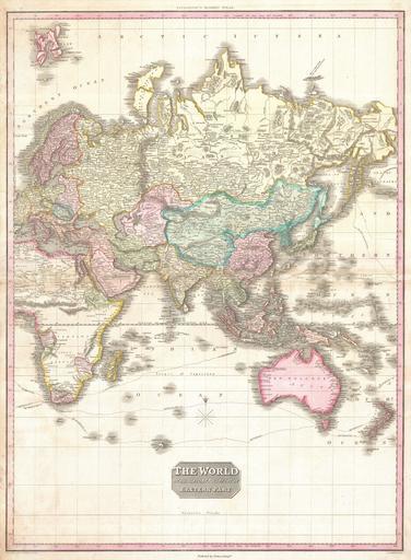
| Keywords: 1818 Pinkerton Map of the Eastern Hemisphere ( Asia , Africa , Europe , Australia) - Geographicus - WorldEH-pinkerton-1818.jpg A rare and important 1818 map of the Eastern Hemisphere by John Pinkerton Depicts Asia Europe Africa and Australia The routes of various important explores are noted including Cook Vancouver Perouse and the return route taken by Cook's ship the Resolution following his death in Hawaii This map offers fairly accurate shorelines throughout In Africa the interior remains unexplored except for the Congo the Cape Colony the gold mining regions of Monomotapa and Abyssinia Similarly the coasts of Australia are accurate but the interior is vague and unknown In Asia there are several notations regarding unexplored territories in southwestern China and Central Asia Far to the north in the high Arctic there is a partial land mass with the note Coast discovered by the Hunters employed by m Liakhov This land refers to the Lyakhov Islands discovered in the 1770s by Russian Fur trader Ivan Lyakhov These islands part of New Siberia were said to have such an abundance of fossilized mammoth ivory that many of the smaller islands were formed from it in their entirety Lyakhov himself brought back 10 000 tons of Ivory on his first trip and subsequent traders are said to have brought back as much as 100 000 tons in the following 20 years Drawn by L Herbert and engraved by Samuel Neele under the direction of John Pinkerton The map comes from the scarce American edition of Pinkerton ôs Modern Atlas published by Thomas Dobson Co of Philadelphia in 1818 1818 undated Size in 21 28 object history credit line accession number WorldEH-pinkerton-1818 Pinkerton J <i>A Modern Atlas from the Lates and Best Authorities Exhibiting the Various Divisions of the World with its chief Empires Kingdoms and States; in Sixty Maps carefully reduced from the Larges and Most Authentic Sources </i> 1818 Philadelphia Thomas Dobson Edition Geographicus-source PD-old-100 Maps by John Pinkerton Old maps of Earth's hemispheres 1818 maps Maps of voyages Maps in English | ||||