MAKE A MEME
View Large Image

| View Original: | 1862_Johnson_Map_of_North_America_-_Geographicus_-_NorthAmerica-johnson-1862.jpg (3945x5000) | |||
| Download: | Original | Medium | Small | Thumb |
| Courtesy of: | commons.wikimedia.org | More Like This | ||
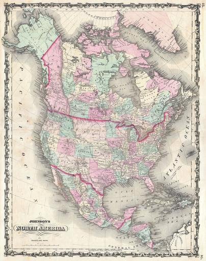
| Keywords: 1862 Johnson Map of North America - Geographicus - NorthAmerica-johnson-1862.jpg A beautiful example of A J Johnson ôs 1862 map of North America Offers a fascinating snapshot of North America particularly the United States Canada and Mexico just after the outbreak of the American Civil War States roughly follow the 1861 configuration with archaic borders between Nevada and California and Nevada and Utah whose capital is noted as Fillmore City This map does not show the fledgling Confederate Territory of Arizona Nebraska extends westward as far as Utah and a massive Washington State borders with Dakota Several important transcontinental routes are shown including the U S Mail Route through Texas and New Mexico and the Pony Express route to Sacramento Also notes numerous American Indian tribes throughout Canada and Mexico are shown in considerable detail with color coding according to region Features the strapwork style border common to Johnson ôs atlas work from 1860 to 1863 Published by A J Johnson and Ward as plate numbers 15 and 16 in the 1862 edition of Johnson ôs New Illustrated Family Atlas This is the first edition of the Johnson ôs Atlas to bear the Johnson Ward imprint 1862 undated Size in 17 5 22 object history credit line accession number s Geographical Statistical and Historical </i> 1862 A J Johnson Ward edition Geographicus-source PD-old-100 Maps by Alvin Jewett Johnson 1862 maps Old maps of North America | ||||