MAKE A MEME
View Large Image

| View Original: | 1865_Spruner_Map_Israel_or_Palestine_post_70_AD.jpg (1353x2180) | |||
| Download: | Original | Medium | Small | Thumb |
| Courtesy of: | commons.wikimedia.org | More Like This | ||
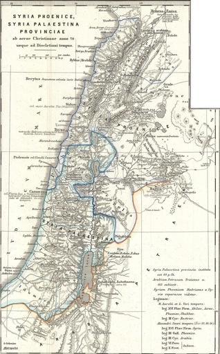
| Keywords: 1865 Spruner Map Israel or Palestine post 70 AD.jpg This is Karl von Spruner ôs 1865 map of the Holy Land or Israel and Palestine Essentially nine maps in one Spruner features two dominant maps and 7 smaller insets including a Peutinger Table in the lower-right quadrant The Peutinger Map is an astoundingly important discovery and is today ôs only known example of a Roman world map though the original Peutinger was itself a mediaeval copy of the Roman original This map also shows in counter-clock wise order from the Peutinger table Galilaea Hierosolyma Judaea Palestine at the time of Herod Syria Arabia and Phoeniciae Palestine and Arabia Many of the insets include their own scale or legend Map notes important cities rivers mountain ranges and other minor topographical detail Territories and countries outlined in color The whole is rendered in finely engraved detail exhibiting throughout the fine craftsmanship of the Perthes firm 1865 undated Size in 13 16 object history credit line accession number Phoenice-spruner-1865 1865_Spruner_Map_of_the_Holy_Land _Israel _or_Palestine_in_Antiquity_-_Geographicus_-_Phoenice-spruner-1865 jpg 50 2013-01-10 08 23 UTC 1865_Spruner_Map_of_the_Holy_Land _Israel _or_Palestine_in_Antiquity_-_Geographicus_-_Phoenice-spruner-1865 jpg Phoenice-spruner-1865 Spruner Karl von <i>Spruner-Menke Atlas Antiquus </i> Gotha Justus Perthes 1865 Geographicus-source derivative work Cristiano64 Map divided into 2/3 parts maps Cristiano64 1865_Spruner_Map_of_the_Holy_Land _Israel _or_Palestine_in_Antiquity_-_Geographicus_-_Phoenice-spruner-1865 jpg PD-old-100 Original upload log This image is a derivative work of the following images File 1865_Spruner_Map_of_the_Holy_Land _Israel _or_Palestine_in_Antiquity_-_Geographicus_-_Phoenice-spruner-1865 jpg licensed with PD-Art 2011-03-25T05 57 05Z BotMultichillT 3500x2897 2712725 Bytes <nowiki> subst User Multichill/Geographicus http //www geographicus com/P/AntiqueMap/Phoenice-spruner-1865 1865 Spruner Map of the Holy Land Israel or Palestine in Antiquity Phoenice Coelesyria Dec</nowiki> Uploaded with derivativeFX 1865 maps Karl Spruner von Merz Old maps of Palestine | ||||