MAKE A MEME
View Large Image
| View Original: | 1867_Mitchell_Map_of_Oregon,_Washington,_Idaho_and_Montana_-_Geographicus_-_WAORIDMT-mitchell-1867.jpg (3500x2874) | |||
| Download: | Original | Medium | Small | Thumb |
| Courtesy of: | commons.wikimedia.org | More Like This | ||
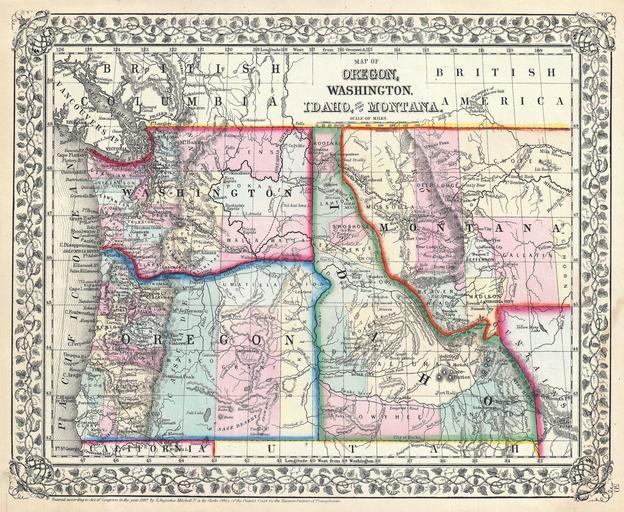
| Keywords: 1867 Mitchell Map of Oregon, Washington, Idaho and Montana - Geographicus - WAORIDMT-mitchell-1867.jpg A beautiful example of S A Mitchell Junior ™s 1867 map of Washington Oregon Idaho and Montana Detailed and color coded at the county level with attention to towns geographical features proposed railroads and cities The Montana-Wyoming border has yet to be fully resolved Features the vine motif border typical of Mitchell maps from the 1865-80 period Prepared for inclusion as plate 50 in the 1867 issue of Mitchell ™s New General Atlas Dated and copyrighted Entered according to Act of Congress in the Year 1867 by S Augustus Mitchell Jr in the Clerk ™s Office of the District Court of the U S for the Eastern District of Pennsylvania 1867 dated Size in 13 5 11 object history credit line accession number WAORIDMT-mitchell-1867 <i>Mitchell's New General Atlas containing maps of the various countries of the World plans of cities etc </i> 1867 edition Geographicus-source PD-old-100 Maps by Samuel Augustus Mitchell Old maps of Idaho Old maps of Montana Old maps of Oregon Old maps of Washington state 1867 maps | ||||