MAKE A MEME
View Large Image

| View Original: | ABANDONED_RUDOLPH_BRUNNOW_TRAIL_-_ACADIA_NATIONAL_PARK.jpg (1488x968) | |||
| Download: | Original | Medium | Small | Thumb |
| Courtesy of: | www.flickr.com | More Like This | ||
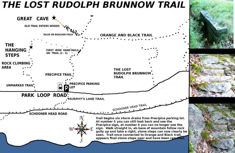
| Keywords: rudolph brunnow rudolphbrunnow acadia national park acadianationalpark abandoned trails abandonedtrails ghost trails ghosttrails lost trails losttrails phantom trails phantomtrails precipice precipice trail precipicetrail great cave greatcave the great cave thegreatcave beehive hanging steps hangingsteps champlain mountain champlainmountain east face trail eastfacetrail the high seas thehighseas acadia mount desert island mountdesertisland park loop road parklooproad maps of acadia mapsofacadia hiking maps of acadia national park hikingmapsofacadianationalpark maine text Very hard trail to locate, even with map and instructions, but it is there as you can see in the photos. Best way to locate area to enter woods, walk against traffic stopping to look back toward the Precipice parking lot at each storm drain. You will still be able to see the Precipice sign by the side of the park loop road. When you reach the storm drain where you look back and can no longer see the precipice sign, that is where the trail begins. You pretty much go right straight back to the base of Champlain Mountain. At that point make your way up a rocky gully as far as you can go, look to the right, there is the worn trail with stone steps. The reason for mapping out this trail is because of the man who built it, Rudolph Brunnow, the same man who gave us such trails as the Champlain East Face Trail, the Precipice Trail, The Beehive, the Hanging Steps and last but not least - the Great Cave trail. But this trail was not designed to be a main trail, it was a secondary trail which began at his front door, The High Seas - which he used to access the other trails he was building. Though its not much as far as trails go, I place this trail at the top of my finds as it was so damn hard to locate and because it was the trail Brunnow used to reach the other areas of his finest work. Sadly trails like the once popular Hanging Steps and the Great Cave loop were abandoned by the Park Service - but these sites can still be located and hiked today. Brunnow himself died from complications following a bad fall from one of his own trails. Very hard trail to locate, even with map and instructions, but it is there as you can see in the photos. Best way to locate area to enter woods, walk against traffic stopping to look back toward the Precipice parking lot at each storm drain. You will still be able to see the Precipice sign by the side of the park loop road. When you reach the storm drain where you look back and can no longer see the precipice sign, that is where the trail begins. You pretty much go right straight back to the base of Champlain Mountain. At that point make your way up a rocky gully as far as you can go, look to the right, there is the worn trail with stone steps. The reason for mapping out this trail is because of the man who built it, Rudolph Brunnow, the same man who gave us such trails as the Champlain East Face Trail, the Precipice Trail, The Beehive, the Hanging Steps and last but not least - the Great Cave trail. But this trail was not designed to be a main trail, it was a secondary trail which began at his front door, The High Seas - which he used to access the other trails he was building. Though its not much as far as trails go, I place this trail at the top of my finds as it was so damn hard to locate and because it was the trail Brunnow used to reach the other areas of his finest work. Sadly trails like the once popular Hanging Steps and the Great Cave loop were abandoned by the Park Service - but these sites can still be located and hiked today. Brunnow himself died from complications following a bad fall from one of his own trails. | ||||