MAKE A MEME
View Large Image

| View Original: | AMH-6057-NA_Map_of_farmlands_in_the_Batavia_area,_part_twenty_five.jpg (2400x1510) | |||
| Download: | Original | Medium | Small | Thumb |
| Courtesy of: | commons.wikimedia.org | More Like This | ||
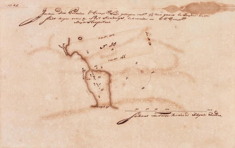
| Keywords: AMH-6057-NA Map of farmlands in the Batavia area, part twenty five.jpg Artwork nl Kaart van landerijen in de omgeving van Batavia deel vijfentwintig nl Titel catalogus Leupe NA Zeekere drie perceelen E Compagnie's land geleegen omtrent 1 5 uur gaans bezuijden deese stadt teegenoover den post Noordwijck behoorendean 's E Comp Buijtehospitaal Het kaartje maakt deel uit van een verzameling van 24 kaartjes en is genummerd no 25 linksboven en in het midden N 25 De nummers 11 20 21 en 26 ontbreken Op de afbeelding een plattegrond met de termen de Groote Revier Rechts een kompas N O Z W en onder een schaalverdeling Schaal van Tweehonderd Rhijns Roeden en Title in the Leupe catalogue NA Zeekere drie perceelen E Compagnie's land geleegen omtrent 1 5 uur gaans bezuijden deese stadt teegenoover den post Noordwijck behoorendean 's E Comp Buijtehospitaal The map is part of a collection of 24 charts and is numbered no 25 top left and in the centre N 25 The numbers 11 20 21 and 26 are missing Depicted is a map containing the label de Groote Revier Right a compass N O Z W and below a scale Schaal van Tweehonderd Rhijns Roeden Atlas of Mutual Heritage na http //www atlasofmutualheritage nl/en/object/ id 6057 Source at the Atlas of Mutual Heritage - http //www gahetna nl/collectie/archief/inventaris/index/eadid/4 VELH/inventarisnr/452 25/level/file Source at the Nationaal Archief en Subjects compass / dial chart / map / plan estate / plantation nl Onderwerpen kompas / windroos plattegrond / kaart landerij / plantage en Fort this image is related to a VOC fort called http //www atlasofmutualheritage nl/en/fort/ id 48 fort Noortwijck Inscription Zeeker Drie Perceelen E Comp Land geleegen omtrent 1 5 Uur gaans beZuyden deese Stadt teegen oover de Post Noordwijck behoordende an 's E Comp Buyten Hospitaal nl between 1689 1709 nl Anoniem / Anonymous en Anoniem / Anonymous Institution Nationaal Archief nl pen en penseel op papier en pen and brush on paper Size cm 27 42 5 accession number NL-HaNA_4 VELH_452 25 old number VELH0452_25 PD-Art-100 Maps of the Dutch East India Company - Indonesia | ||||