MAKE A MEME
View Large Image

| View Original: | AMH-6712-KB_Map_of_the_city_and_fort_of_Puerto_Rico.jpg (2400x1881) | |||
| Download: | Original | Medium | Small | Thumb |
| Courtesy of: | commons.wikimedia.org | More Like This | ||
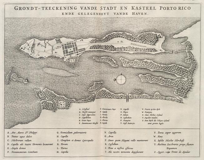
| Keywords: AMH-6712-KB Map of the city and fort of Puerto Rico.jpg Artwork nl Plattegrond van stad en fort Porto Rico nl Plattegrond van stad en fort Porto Rico Grondt-teekening vande Stadt en Kasteel Porto rico ende gelegenheyt vande Haven In San Juan Porto Rico is alleen het kleine fort Canuela in 1625 een paar maanden in Nederlandse handen geweest De legenda staat in het Latijn en het Nederlands op de kaart Legenda A t' Casteel / B Versch-waterput / C Onse Approchen loopgraven / D Capelleken / E Groot huys / F Dominicaner klooster / G Gouverneurs huys / H Capelle / I Kercke / K Merckt / L Haeven / M Capelle / N Capelle / O Playn / P Inham / R Casteeltien / S Fonteyne / T Onse Batterye / V Poorte op den dyck / W Fonteyne / X Claes Herkes Eijland / Y Suycker meulen / Z Den Dyck die 't kleyn Eyland aent groote heght en Map of the city and fort of Puerto Rico Grondt-teekening vande Stadt en Kasteel Porto rico ende gelegenheyt vande Haven The Dutch held the small fort of Canuela in San Juan Puerto Rico for only a couple of months in 1625 The chart gives the key in Latin and Dutch Key A t' Casteel / B Versch-waterput / C Onse Approchen trenches / D Capelleken / E Groot huys / F Dominicaner klooster / G Gouverneurs huys / H Capelle / I Kercke / K Merckt / L Haeven / M Capelle / N Capelle / O Playn / P Inham / R Casteeltien / S Fonteyne / T Onse Batterye / V Poorte op den dyck / W Fonteyne / X Claes Herkes Eijland / Y Suycker meulen / Z Den Dyck die 't kleyn Eyland aent groote heght Atlas of Mutual Heritage kb http //www atlasofmutualheritage nl/en/object/ id 6712 Source at the Atlas of Mutual Heritage en Subjects fortification tanck / well / watering hole building compass / dial key monastery / seminary chart / map / plan church / parsonage house bird's-eye view / elevation elevation / bird's-eye view nl Onderwerpen vesting tanck / waterplaats / put gebouw kompas / windroos legenda klooster / seminarie plattegrond / kaart kerk / pastorie huis / woonhuis vogelvlucht / opstand opstand / vogelvlucht en Post this image is related to a WIC trading post called http //www atlasofmutualheritage nl/en/post/ id 1058 San Juan Inscription Grondt-teekening vande Stadt en Kasteel Porto rico ende gelegenheyt vande Haven nl circa 1644 Creator B Elsevier Creator I Elsevier nl Anoniem / Anonymous landmeter / kaartenmaker B Elsevier uitgever I Elsevier uitgever en Anoniem / Anonymous land surveyor / mapmaker B Elsevier publisher I Elsevier publisher Institution Koninklijke Bibliotheek nl gravure op papier en engraving on paper Size cm 34 26 5 accession number 40 E 7 na p 58 2 PD-Art-100 Maps of the West-Indische Compagnie 1644 | ||||