MAKE A MEME
View Large Image

| View Original: | DayLength.svg (495x393) | |||
| Download: | Original | Medium | Small | Thumb |
| Courtesy of: | commons.wikimedia.org | More Like This | ||
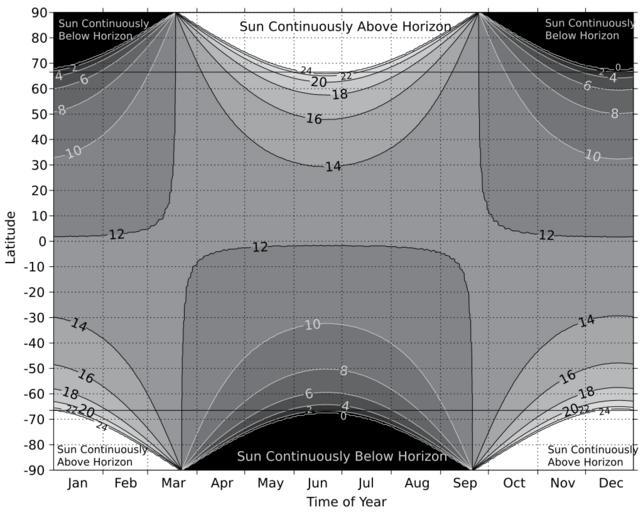
| Keywords: DayLength.svg Length of day sunrise to sunset in hours as a function of latitude and time of year Sunrise and sunset times were calculated using the FORTRAN program sunae f found at ftp //climate1 gsfc nasa gov/wiscombe/Solar_Rad/SunAngles/sunae f Atmospheric refraction appropriate for the US Standard Atmosphere is applied at all latitudes though the correction should vary by latitude and time of year Contours are not necessarily smooth because of the 0 5-degree latitude spacing used in the calculations Calculations were performed for the 365 days in 2007 on the Greenwich Meridian For each minute during 2007 the sun's elevation the angle between a flat horizon and the apparent location of the center of the sun accounting for refraction was calculated at -90 -89 5 -89 89 5 and 90° latitude and 0° longitude The sunrise time was found by linearly interpolating to the time when the solar elevation was 0° going from negative to positive; the sunset time was found the same way but for the elevation going from positive to negative This ignores the fact that the diameter of the sun is about 0 5° meaning the top of the sun does not drop below the horizon until the solar elevation is -0 25° Ignoring the diameter of the sun slightly shortens the calculated length of the day but the difference is not significant when plotted on this scale Own 2007-09-05 StephenHudson PNG version that loads much more easily on my browsers is available Image DayLength png Day length | ||||