MAKE A MEME
View Large Image

| View Original: | Der Aufbau der Republik Deutschösterreich.png (1129x594) | |||
| Download: | Original | Medium | Small | Thumb |
| Courtesy of: | commons.wikimedia.org | More Like This | ||
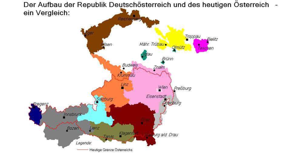
| Keywords: Der Aufbau der Republik Deutschösterreich.png DarkOrange Provinz Oberösterreich 15 162 km² 1 03 Millionen Einwohner 1910 bekannten sich fĂ¼r das ehemalige Kronland Ă–sterreich ob der Enns ohne DeutschsĂ¼dböhmen 99 7 der Einwohner als Deutsche und 0 2 als Tschechen Violet Provinz Niederösterreich 22 048 km² 3 72 Millionen Einwohner 1910 bekannten sich fĂ¼r das ehemalige Kronland Ă–sterreich unter der Enns ohne den Deutsch-SĂ¼dmährischen Kreis 95 5 als Deutsche und 3 7 als Tschechen 0 1 gaben ein anderes Volkstum an SaddleBrown Provinz Deutschböhmen 14 496 km² 2 23 Millionen Einwohner 1919 bekannten sich von den Einwohnern 2 07 Millionen als Deutsche und 116 275 als Tschechen Yellow Provinz Sudetenland 6 534 km² 678 880 Einwohner 1919 bekannten sich von den Einwohnern 643 804 als Deutsche 25 028 als Tschechen und 5 200 als Polen Maroon Provinz Steiermark 22 426 km² 1 44 Millionen Einwohner 1910 bekannten sich von den Einwohnern 70 5 als Deutsche und 29 5 als Slowenen Aqua Provinz Salzburg 7 153 km² 214 997 Einwohner 1910 bekannten sich 99 7 der Einwohner als Deutsche DarkOliveGreen Provinz Kärnten 10 327 km² 394 735 Einwohner 1910 bekannten sich 78 6 als Deutsche und 21 4 als Slowenen DarkGray Provinz Deutschtirol 20 047 km² 1 09 Millionen Einwohner 1910 bekannten sich in der Provinz 839 000 als Deutsche 20 000 als Ladiner und 3 000 als Italiener Navy Provinz Vorarlberg 2 602 km² 145 794 Einwohner 1910 bekannten sich von den Einwohnern 95 als Deutsche und 5 als Italiener Green Die Einschlussgebiete Deutschösterreichs Iglau 374 km² 31 000 Einwohner 1920 Davon 17 000 Tschechen und 14 000 Deutsche BrĂ¼nn 70 km² 263 600 Einwohner 1920 Davon 209 600 Tschechen und 54 000 Deutsche OlmĂ¼tz 42 km² 66 400 Einwohner 1920 Davon 51 400 Tschechen und 15 000 Deutsche Von Deutschösterreich formal beanspruchte Gebiete LightGrey Deutschwestungarn HotPink Ostschlesien gemeinschaftliche Verwaltung mit Polen und der Tschechoslowakei vorgeschlagen DarkOrange Province of Upper Austria 15 162 km² 1 03 million inhabitant In 1910 99 7 of the inhabitants of the former Crown Land of Austria Beyond the Enns identified themselves as Germans and 0 2 as Czechs Violet Province of Lower Austria 22 048 km² 3 72 million inhabitant In 1910 95 5 of the inhabitants of the former Crown Land of Austria Under the Enns without the area of German Southen Moravia identified as Germans and 3 7 as Czechs 0 1 indicated another nationality SaddleBrown Province of German Bohemia 14 496 km² 2 23 million inhabitant In 1919 2 07 million identified themselves as Germans and 116 275 as Czechs Yellow Province of Sudetenland 6 534 km² 678 880 inhabitants In 1919 643 804 identified themselves as Germans 25 028 as Czechs and 5 200 as Poles Maroon Province of Styria 22 426 km² 1 44 million inhabitant In 1910 70 5 of the inhabitants identified themselves as Germans and 29 5 as Slovenes Aqua Province of Salzburg 7 153 km² 214 997 inhabitants In 1910 99 7 of the inhabitants identified themselves as Germans DarkOliveGreen Province of Carinthia 10 327 km² 394 735 inhabitants In 1910 78 6 of the inhabitants identified themselves as Germans and 21 4 as Slovenes DarkGray Province of German Tyrol 20 047 km² 1 09 million inhabitant In 1910 839 000 of the inhabitants identified themselves as Germans 20 000 as Ladiner and 3 000 as Italians Navy Province of Vorarlberg 2 602 km² 145 794 inhabitants In 1910 95 of the inhabitants identified themselves as Germans and 5 as Italians Green The inclusion areas of German-Austria Iglau 374 km² 31 000 inhabitants 1920 Thereof 17 000 Czechs and 14 000 Germans Bruenn 70 km² 263 600 inhabitants 1920 Thereof 209 600 Czechs and 54 000 Germans Olmuetz 42 km² 66 400 inhabitants 1920 Thereof 51 400 Czechs and 15 000 Germans Areas officially claimed by German-Austria LightGrey German West Hungary HotPink East Silesia joint administration with Poland and Czechoslovakia suggested Border of the subsequent First Austrian Republic and modern Austria 1px solid red Own work<br/> Data sources Fibel zur Deutschlandfrage Vol 1 Hermann Schroedel Verlag KG Berlin Hanover Darmstadt 1962 ; Der GroĂŸe Brockhaus Vol 1-4 1938 ; Alexander Sixtus von Reden Ă–sterreich-Ungarn - Die Donaumonacharchie in historischen Dokumenten Verlag Carl Ueberreuter 1995 Renate Basch Ritter Ă–sterreich-Ungarn in Wort und Bild« Menschen und Länder Verlag Styria 1989 Quellen »Fibel zur Deutschlandfrage« Bd 1 vom Hermann Schroedel Verlag KG Berlin-Hannover-Darmstadt 1962 ; »Der GroĂŸe Brockhaus« Bd 1-4 1938 ; Alexander Sixtus von Reden »Österreich-Ungarn - Die Donaumonacharchie in historischen Dokumenten« Verlag Carl Ă berreuter 1995 Renate Basch-Ritter »Österreich-Ungarn in Wort und Bild« Menschen und Länder Verlag Styria 1989 2006-03-02 02 46 Postmann Michael Postmann Michael <gallery>File Deutschösterreich1 png Deutschösterreich1 png</gallery> historical map Maps of the history of Austria Maps of the history of Burgenland Sudetenland | ||||