MAKE A MEME
View Large Image

| View Original: | General_Map_of_Central_Asia-Schematic_View_(1874).jpg (6599x6625) | |||
| Download: | Original | Medium | Small | Thumb |
| Courtesy of: | commons.wikimedia.org | More Like This | ||
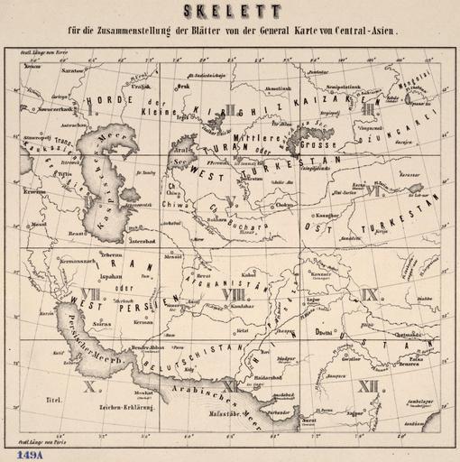
| Keywords: General Map of Central Asia-Schematic View (1874).jpg Kurztitel General-Karte von Central-Asien; Vollst├żndiger Titel General-Karte von Central-Asien bearbeitet nach den besten und neuesten Russischen und Englischen quellen <br />General-Karte von Central-Asien ö Schematischen Ansicht Ma├¤stab 1 3 024 000; Ma├¤e 125 x 137 cm <br /> General ōKarte von Central ōAsien ist eine gro├¤e detaillierte Karte im Jahre 1874 von der Milit├żr Geographischen Institut Wien produziert Die Karte ist auf 12 getrennten Platten nummeriert I-XII; ein 13 Platte gibt einen ├ berblick und eine nummerierte Anleitung wie die Teile zusammenpassen Die Karte deckt eine riesige Fl├żche im Nordwesten von der russischen Region n├Črdlich des Kaspischen Meeres begrenzt ist; im S├╝dwesten von heutigen Saudi-Arabien und Oman; nord├Čstlich von der westlichen Mongolei; und im S├╝dosten von Gujarat Indien Der Titel Zeichenerkl├żrung und Erkl├żrung der Abk├╝rzungen sind auf Tafel X in der unteren linken s├╝dwestlichen Ecke Sieben Schuppen in verschiedenen L├żngeneinheiten Englisch Italienisch Russisch T├╝rkisch Persisch Chinesisch und metrischen vorgesehen sind an der Unterseite der Platte XII Die gezeigten Merkmale sind St├żdte und Gemeinden; nationalen und provinziellen Grenzen; T├╝rme Burgen und Ruinen; bestehende und geplante Eisenbahnstrecken; Telegrafenleitungen; und Stra├¤en Nach dem Titel wird die Karte mit den besten und neuesten russischen und englischen Quellen ├╝berarbeitet Russland und die British Empire waren Rivalen um Einfluss in Zentralasien in was sp├żter als The Great Game und sie spezielles Know-how hatten ├╝ber die Region gewonnenen wissenschaftlichen und milit├żrischen Expeditionen und Handelskontakte Short Title General Map of Central Asia; Full Title General map of Central Asia edited based on the best and the newest Russian and English sources <br />General map of Central Asia ö Schematic View Scale 1 3 024 000; Dimension 125 ├Ś 137 cm <br /> General map of Central Asia is a large detailed map produced in 1874 by the Military Geographic Institute of Vienna The map is on 12 separate plates numbered I ōXII; a 13th plate gives an overview and a numbered guide to how the parts fit together The map covers a huge expanse bounded to the northwest by the region of Russia north of the Caspian Sea; to the southwest by present-day Saudi Arabia and Oman; to the northeast by western Mongolia; and to the southeast by Gujarat India The title key to symbols and explanation of abbreviations are on Plate X in the lower left-hand southwestern corner Seven scales in different distance units English Italian Russian Turkish Persian Chinese and metric are provided at the bottom of Plate XII The features shown include cities and towns; national and provincial borders; towers fortresses and ruins; existing and projected railroads; telegraph lines; and roads According to the title the map is revised with the best and newest Russian and English sources Russia and the British Empire were rivals for influence in Central Asia in what came to be called the Great Game and they had special expertise about the region gained from scientific and military expeditions and commercial contacts ąÜč ą░čéą║ąŠąĄ ąĮą░ąĘą▓ą░ąĮąĖąĄ ą×ą▒čēą░čÅ ą║ą░č čéą░ ą”ąĄąĮčéč ą░ą╗čīąĮąŠą╣ ąÉąĘąĖąĖ; ą¤ąŠą╗ąĮąŠąĄ ąĮą░ąĘą▓ą░ąĮąĖąĄ ą×ą▒čēą░čÅ ą║ą░č čéą░ ą”ąĄąĮčéč ą░ą╗čīąĮąŠą╣ ąÉąĘąĖąĖ ąŠčéč ąĄą┤ą░ą║čéąĖč ąŠą▓ą░ąĮąĮą░čÅ čü čāč湥č鹊ą╝ ą╗čāčćčłąĖčģ ąĖ ąĮąŠą▓ąĄą╣čłąĖčģ č ąŠčüčüąĖą╣čüą║ąĖčģ ąĖ ą░ąĮą│ą╗ąĖą╣čüą║ąĖčģ ąĖčüč鹊čćąĮąĖą║ąŠą▓ <br />ą×ą▒čēą░čÅ ą║ą░č čéą░ ą”ąĄąĮčéč ą░ą╗čīąĮąŠą╣ ąÉąĘąĖąĖ ö ąĪčģąĄą╝ą░čéąĖč湥čüą║ąĖą╣ ą▓ąĖą┤ ą ą░čüčłčéą░ą▒ 1 3 024 000; ąĀą░ąĘą╝ąĄč čŗ 125 ├Ś 137 čüą╝ <br /> ą×ą▒čēą░čÅ ą║ą░č čéą░ ą”ąĄąĮčéč ą░ą╗čīąĮąŠą╣ ąÉąĘąĖąĖ ą┐č ąĄą┤čüčéą░ą▓ą╗čÅąĄčé čüąŠą▒ąŠą╣ ą▒ąŠą╗čīčłčāčÄ ą┐ąŠą┤č ąŠą▒ąĮčāčÄ ą║ą░č čéčā ą▓čŗą┐čāčēąĄąĮąĮčāčÄ ą▓ 1874 ą│ ąÆąŠąĄąĮąĮčŗą╝ ą│ąĄąŠą│č ą░čäąĖč湥čüą║ąĖą╝ ąĖąĮčüčéąĖčéčāč鹊ą╝ ą▓ ąÆąĄąĮąĄ ąÜą░č čéą░ ąĘą░ąĮąĖą╝ą░ąĄčé 12 ąŠčéą┤ąĄą╗čīąĮčŗčģ ą╗ąĖčüč鹊ą▓ ą┐č ąŠąĮčāą╝ąĄč ąŠą▓ą░ąĮąĮčŗčģ ąŠčé I ą┤ąŠ XII; ąĮą░ 13-ą╝ ą╗ąĖčüč鹥 ą┐č ąĄą┤ąŠčüčéą░ą▓ą╗ąĄąĮą░ ąŠą▒čēą░čÅ ąĖąĮčäąŠč ą╝ą░čåąĖčÅ ąĖ č čāą║ąŠą▓ąŠą┤čüčéą▓ąŠ čü ąĮčāą╝ąĄč ą░čåąĖąĄą╣ ą┤ą╗čÅ čüąŠąĄą┤ąĖąĮąĄąĮąĖčÅ čćą░čüč鹥ą╣ ąÜą░č čéą░ ąŠčģą▓ą░čéčŗą▓ą░ąĄčé ąŠą▒čłąĖč ąĮčŗą╣ č ąĄą│ąĖąŠąĮ ąĮą░ čüąĄą▓ąĄč ąŠ-ąĘą░ą┐ą░ą┤ąĄ ąŠąĮ ą│č ą░ąĮąĖčćąĖčé čü č鹥č č ąĖčéąŠč ąĖąĄą╣ ąĀąŠčüčüąĖąĖ ą║ čüąĄą▓ąĄč čā ąŠčé ąÜą░čüą┐ąĖą╣čüą║ąŠą│ąŠ ą╝ąŠč čÅ; ąĮą░ čÄą│ąŠ-ąĘą░ą┐ą░ą┤ąĄ ö čü č鹥č č ąĖčéąŠč ąĖąĄą╣ čüąŠą▓č ąĄą╝ąĄąĮąĮąŠą╣ ąĪą░čāą┤ąŠą▓čüą║ąŠą╣ ąÉč ą░ą▓ąĖąĖ ąĖ ą×ą╝ą░ąĮą░ ąĮą░ čüąĄą▓ąĄč ąŠ-ą▓ąŠčüč鹊ą║ąĄ ö čü ąŚą░ą┐ą░ą┤ąĮąŠą╣ ą ąŠąĮą│ąŠą╗ąĖąĄą╣ ą░ ąĮą░ čÄą│ąŠ-ą▓ąŠčüč鹊ą║ąĄ ö čü ą┐č ąŠą▓ąĖąĮčåąĖąĄą╣ ąōčāą┤ąČą░č ą░čé ąśąĮą┤ąĖčÅ ą ą░ąĘą▓ą░ąĮąĖąĄ ą║ą╗čÄčć ą║ čüąĖą╝ą▓ąŠą╗ą░ą╝ ąĖ ą┐ąŠčÅčüąĮąĄąĮąĖčÅ ą║ čüąŠą║č ą░čēąĄąĮąĖčÅą╝ ą┐č ąĖą▓ąŠą┤čÅčéčüčÅ ąĮą░ ąøąĖčüč鹥 X ą▓ ą╗ąĄą▓ąŠą╝ ąĮąĖąČąĮąĄą╝ čāą│ą╗čā čÄą│ąŠ-ąĘą░ą┐ą░ą┤ ą ą░čüčłčéą░ą▒ čāą║ą░ąĘą░ąĮ ą▓ čüąĄą╝ąĖ č ą░ąĘą╗ąĖčćąĮčŗčģ ąĄą┤ąĖąĮąĖčåą░čģ ąĖąĘą╝ąĄč ąĄąĮąĖčÅ ą░ąĮą│ą╗ąĖą╣čüą║ąĖčģ ąĖčéą░ą╗čīčÅąĮčüą║ąĖčģ č čāčüčüą║ąĖčģ čéčāč ąĄčåą║ąĖčģ ą┐ąĄč čüąĖą┤čüą║ąĖčģ ą║ąĖčéą░ą╣čüą║ąĖčģ ąĖ ą╝ąĄčéč ąĖč湥čüą║ąĖčģ ą▓ ąĮąĖąČąĮąĄą╣ čćą░čüčéąĖ ąøąĖčüčéą░ XII ąÆ čćąĖčüą╗ąŠ ąŠą▒čŖąĄą║č鹊ą▓ ąĮą░ ą║ą░č č鹥 ą▓čģąŠą┤čÅčé ą▒ąŠą╗čīčłąĖąĄ ąĖ ą╝ą░ą╗čŗąĄ ą│ąŠč ąŠą┤ą░; ą│č ą░ąĮąĖčåčŗ ą│ąŠčüčāą┤ą░č čüčéą▓ ąĖ ą┐č ąŠą▓ąĖąĮčåąĖą╣; ą▒ą░čłąĮąĖ ą║č ąĄą┐ąŠčüčéąĖ ąĖ č čāąĖąĮčŗ; čüčāčēąĄčüčéą▓čāčÄčēąĖąĄ ąĖ ą┐č ąŠąĄą║čéąĖč čāąĄą╝čŗąĄ ąČąĄą╗ąĄąĘąĮčŗąĄ ą┤ąŠč ąŠą│ąĖ; č鹥ą╗ąĄą│č ą░čäąĮčŗąĄ ą╗ąĖąĮąĖąĖ ąĖ ą┤ąŠč ąŠą│ąĖ ąśąĘ ąĮą░ąĘą▓ą░ąĮąĖčÅ čüą╗ąĄą┤čāąĄčé čćč鹊 ą║ą░č čéą░ ą▒čŗą╗ą░ ą┐ąĄč ąĄčüą╝ąŠčéč ąĄąĮą░ čü čāč湥č鹊ą╝ ą╗čāčćčłąĖčģ ąĖ ąĮąŠą▓ąĄą╣čłąĖčģ č ąŠčüčüąĖą╣čüą║ąĖčģ ąĖ ą░ąĮą│ą╗ąĖą╣čüą║ąĖčģ ąĖčüč鹊čćąĮąĖą║ąŠą▓ ąĀąŠčüčüąĖą╣čüą║ą░čÅ ąĖ ąæč ąĖčéą░ąĮčüą║ą░čÅ ąĖą╝ą┐ąĄč ąĖąĖ čüąŠą┐ąĄč ąĮąĖčćą░ą╗ąĖ ąĘą░ čāčüčéą░ąĮąŠą▓ą╗ąĄąĮąĖąĄ ą▓ą╗ąĖčÅąĮąĖčÅ ą▓ ą”ąĄąĮčéč ą░ą╗čīąĮąŠą╣ ąÉąĘąĖąĖ ą▓ąĄą╗ąĖ čéą░ą║ ąĮą░ąĘčŗą▓ą░ąĄą╝čāčÄ ąæąŠą╗čīčłčāčÄ ąĖą│č čā ą×ąĮąĖ ąŠč湥ąĮčī čģąŠč ąŠčłąŠ ąĘąĮą░ą╗ąĖ č ąĄą│ąĖąŠąĮ ą▒ą╗ą░ą│ąŠą┤ą░č čÅ ą┤ą░ąĮąĮčŗą╝ ą┐ąŠą╗čāč湥ąĮąĮčŗą╝ ą▓ čģąŠą┤ąĄ ąĮą░čāčćąĮčŗčģ ąĖ ą▓ąŠąĄąĮąĮčŗčģ 菹║čüą┐ąĄą┤ąĖčåąĖą╣ ą░ čéą░ą║ąČąĄ ą▓ č ąĄąĘčāą╗čīčéą░č鹥 ą║ąŠą╝ą╝ąĄč č湥čüą║ąĖčģ ą║ąŠąĮčéą░ą║č鹊ą▓ LOC-map g7420m gct00290 ├¢sterreichisch-Ungarische Monarchie Kaiserlich ōk├Čniglich Milit├żrgeographisches Institut in Wien Austro ōHungarian Monarchy Imperial ōRoyal Military Geographic Institute in Vienna ąÉą▓čüčéč ąŠ ōąÆąĄąĮą│ąĄč čüą║ą░čÅ ą╝ąŠąĮą░č čģąĖčÅ ąśą╝ą┐ąĄč ą░č鹊č čüą║ąŠ ōąÜąŠč ąŠą╗ąĄą▓čüą║ąĖą╣ ą▓ąŠąĄąĮąĮąŠ-ą│ąĄąŠą│č ą░čäąĖč湥čüą║ąĖą╣ ąĖąĮčüčéąĖčéčāčé ą▓ ąÆąĄ╠üąĮąĄ 1874 <gallery> File General Map of Central Asia - Plate 3 1874 jpg File General Map of Central Asia - Plate 4 1874 jpg File General Map of Central Asia - Plate 5 1874 jpg File General Map of Central Asia - Plate 7 1874 jpg </gallery> PD-Art-100 Uploaded with UploadWizard Old maps of the Middle East Old maps of Turkmenistan Old maps of Uzbekistan Old maps of Afghanistan Old maps of Kazakhstan Old maps of Kyrgyzstan Old maps of Tajikistan Old maps of the Indian Subcontinent 1874 maps | ||||