MAKE A MEME
View Large Image

| View Original: | Global spread of H5N1 map.svg (863x442) | |||
| Download: | Original | Medium | Small | Thumb |
| Courtesy of: | commons.wikimedia.org | More Like This | ||
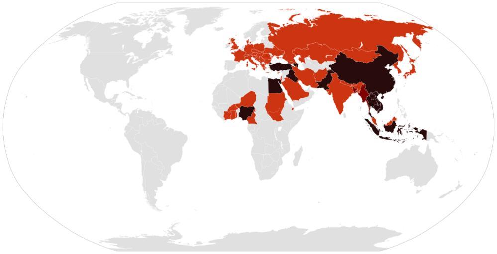
| Keywords: Global spread of H5N1 map.svg 280b0c Countries with humans poultry and wild birds killed by H5N1 800000 Countries with poultry or wild birds killed by H5N1 and has reported human cases of H5N1 cd3412 Countries with poultry or wild birds killed by H5N1 Own work Derived from Global spread of H5N1 map PNG and BlankMap-World6 svg by User Shizhao and w en User Canuckguy on 2006-02-17 and 2006-11-12 respectively <nowiki>Former released under GFDL and latter under </nowiki> Cflm001 <span class signature-talk >talk</span> cwi 2009-05-03 Global spread of H5N1 map PNG File history of Global spread of H5N1 map PNG 05 18 15 May 2007 1 425Ă—625 49 KB Zntrip Talk contribs Added some countries listed on Wikipedia Bangladesh and Ghana removed Jordon 14 58 6 March 2007 1 425Ă—625 31 KB Aivazovsky Talk contribs 13 51 5 February 2007 1 350Ă—625 30 KB Verdy p Talk contribs confirmed human death in Nigeria see WHO report for 3 february 2007 23 50 7 July 2006 1 350Ă—625 54 KB Zntrip Talk contribs Added Spain 18 32 23 May 2006 1 350Ă—625 54 KB Verdy p Talk contribs Import the 15 May update from English Wikipedia 14 20 2 May 2006 1 350Ă—625 54 KB Verdy p Talk contribs import the 27 April update from English wikipedia adds CĂ´te d'Ivoire 14 47 6 April 2006 1 357Ă—628 31 KB Wangi Talk contribs Add UK 02 03 30 March 2006 800Ă—370 91 KB Cinik Talk contribs only update from en H5N1 confirmated in Czech republic 05 36 28 March 2006 1 357Ă—628 30 KB Verdy p Talk contribs Import depuis English Wikipedia 09 11 24 March 2006 1 357Ă—628 59 KB Verdy p Talk contribs 08 43 17 Feb<nowiki>ruary 2006 1 357Ă—628 46 KB Shizhao Talk contribs Summary I made this map by using Image BlankMap-World png Dark red areas have confirmed human cases and light red have bird cases either in poultry or wild birds “ Zntrip 00 07 16 February 2006 UTC Licensing GFDL-self </nowiki> Disease incidence world maps SVG maps of the world Avian influenza maps | ||||