MAKE A MEME
View Large Image

| View Original: | Golan Trail en.png (448x855) | |||
| Download: | Original | Medium | Small | Thumb |
| Courtesy of: | commons.wikimedia.org | More Like This | ||
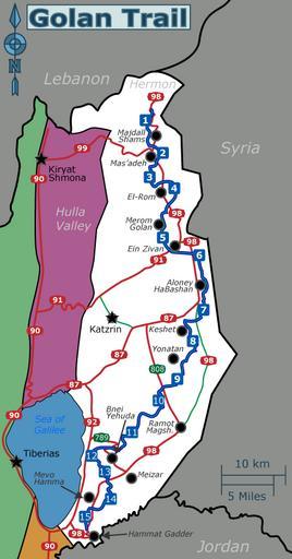
| Keywords: Golan Trail en.png en Schematic map of the Golan Heights showing main roads several settlements and the Golan Trail marked with a dotted green line with trail-section numbers 2013-08-27 02 32 30 own Tamuz SVG source File Golan Trail en he svg Image map you can use for clicking the numbered buttons <nowiki><imagemap></nowiki> Image Golan Trail en png thumb 448px The Golan Trail is marked by a green dotted line Click on a section number to visit it rect 213 173 231 192 <nowiki> 1</nowiki> rect 240 224 258 242 <nowiki> 2</nowiki> rect 219 260 238 280 <nowiki> 3</nowiki> rect 258 278 276 297 <nowiki> 4</nowiki> rect 241 354 259 372 <nowiki> 5</nowiki> rect 294 380 315 399 <nowiki> 6</nowiki> rect 304 464 321 483 <nowiki> 7</nowiki> rect 287 512 305 531 <nowiki> 8</nowiki> rect 264 571 281 589 <nowiki> 9</nowiki> rect 235 604 252 622 <nowiki> 10</nowiki> rect 195 653 212 671 <nowiki> 11</nowiki> rect 132 689 150 706 <nowiki> 12</nowiki> rect 152 713 170 731 <nowiki> 13</nowiki> rect 162 755 179 772 <nowiki> 14</nowiki> rect 122 782 140 799 <nowiki> 15</nowiki> desc top-right </imagemap> cc-zero Uploaded with UploadWizard Maps of the Golan Heights Golan Trail | ||||