MAKE A MEME
View Large Image

| View Original: | Greater Japanese empire.png (1004x1004) | |||
| Download: | Original | Medium | Small | Thumb |
| Courtesy of: | commons.wikimedia.org | More Like This | ||
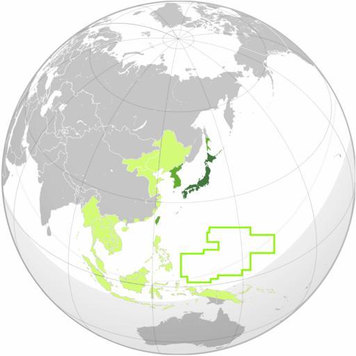
| Keywords: Greater Japanese empire.png w South Pacific Mandate borders need to be redrawn to proper geocoordinates with curve Japanese Empire orthographic projection svg Japanese Empire at its peak 1942/1943 <br> Green Great Japanese Empire<br>Lime Japanese colonies/mandates<br>Light lime Puppet states and occupied territory of Japan en wikipedia Sreejithk2000 CommonsHelper 2010-06-03 VoodooIsland wikipedia en VoodooIsland original upload log page en wikipedia Greater_Japanese_empire png 2010-06-03 10 42 VoodooIsland 1000×1000× 302963 bytes <nowiki>minor China-Nanjing northern border extension</nowiki> 2010-06-03 10 30 VoodooIsland 1000×1000× 302922 bytes <nowiki>China-Nanjing/Mengjiang border adjustment</nowiki> 2010-06-03 10 12 VoodooIsland 1000×1000× 302946 bytes <nowiki></nowiki> 2010-06-03 10 11 VoodooIsland 1000×1000× 302962 bytes <nowiki></nowiki> 2010-06-03 10 09 VoodooIsland 1000×1000× 302985 bytes <nowiki></nowiki> 2010-06-03 10 05 VoodooIsland 1000×1000× 303012 bytes <nowiki></nowiki> 2010-06-03 10 04 VoodooIsland 1000×1000× 305110 bytes <nowiki>Green Great Japanese Empire<br>Lime Japanese colonies/mandates<br>Light lime Puppet states and occupied territory of Japan</nowiki> 1942 1943 Japan in the 20th century Maps of the Empire of Japan Maps showing 20th-century history | ||||