MAKE A MEME
View Large Image

| View Original: | Iberian Peninsula in 125-en.svg (720x576) | |||
| Download: | Original | Medium | Small | Thumb |
| Courtesy of: | commons.wikimedia.org | More Like This | ||
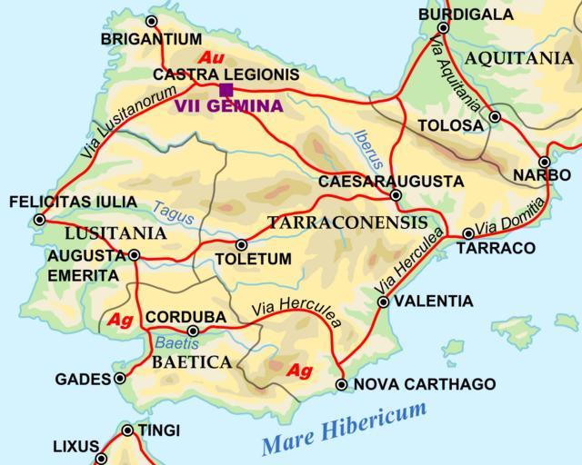
| Keywords: Iberian Peninsula in 125-en.svg Shows Iberian peninsula in 125 including important roads legionnaire locations and gold/silver mines NOTE Barbarian names and locations as in the works of Tacitus written ca 100 AD Roman_Empire_125 svg 2009-03-28 Roman_Empire_125 svg Andrei nacu derivative work Richardprins <span class signature-talk >talk</span> SVG Support This document is in the Scalable Vector Graphic format SVG and requires a supported browser Firefox Google Chrome Opera or a SVG plugin for Internet Explorer and other browsers SVG is an open source format which means this map can be downloaded and modified/translated completely using a vector graphics editor like Adobe Illustrator or Inkscape free or a text editor such as Notepad wikitable background red; color white align center BLANK THUMBNAIL View large PNG View medium PNG SVG Plugin for Internet Explorer and other browsers - <span class plainlinks > fullurl FULLPAGENAME purge Click here purge cache </span> and then CTRL+F5 to reload Help http //upload wikimedia org/wikipedia/commons/thumb/a/ab/ PAGENAMEE /2048px- PAGENAMEE png Try 1 http //upload wikimedia org/wikipedia/commons/thumb/b/ab/ PAGENAMEE /1024px- PAGENAMEE png Try 2 http //upload wikimedia org/wikipedia/commons/thumb/a/ab/ PAGENAMEE /900px- PAGENAMEE png Try 1 http //upload wikimedia org/wikipedia/commons/thumb/b/ab/ PAGENAMEE /900px- PAGENAMEE png Try 2 http //www adobe com/svg/viewer/install/ Adobe SVG plugin - Recommended browser More Help - http //www firefox com/ Firefox http //www openclipart org/wiki/SVG_Tools List of SVG tools <noinclude> Zoomed in to Iberian peninsula Roman_Empire_125 svg original upload log This image is a derivative work of the following images File Roman_Empire_125 svg licensed with PD-user-en PD-user-w PD-user-w/de Uploaded with derivativeFX 125 in Europe Baetica Maps of Lusitania Maps of Roman Hispania Maps showing history in Latin Spain in the 2nd century 125 SVG maps in Latin SVG maps showing history | ||||