MAKE A MEME
View Large Image

| View Original: | Map Palestinian territories acquired by war Not annexed to Israel.jpg (2828x8208) | |||
| Download: | Original | Medium | Small | Thumb |
| Courtesy of: | commons.wikimedia.org | More Like This | ||
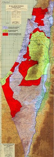
| Keywords: Map Palestinian territories acquired by war Not annexed to Israel.jpg en Map of Palestinian territories under Israeli military control by 1949 approximation only The territories have never been annexed to Israel Derivative work based on map of Palestine compiled drawn and printed by the Survey of Palestine in 1944 with updates to roads in January 1946 The original was created under the British Mandate Government in Palestine and published in August 1944 according to http //cosmos ucc ie/cs1064/jabowen/IPSC/php/map php mid 131 See also http //www palestineremembered com/Acre/Maps/Story582 html Modifications to the original based on the UNGA Resolution 181 text for the recommended boundaries of the proposed stateshttp //books google com au/books id NmXBmOGbHL4C pg PA104 dq UNGA+resolution+181 hl en ei kgmtTZqZH4zOvQOG75XtCg sa X oi book_result ct result resnum 7 sqi 2 ved 0CEYQ6AEwBg v onepage q resolution 20181 f false Page 6 http //mideastweb org/palestine_partition_map_1947s jpg by Talknic Survey of Palestine; Talknic 2010-11-24 Cc-zero Maps of the Palestinian territories | ||||