MAKE A MEME
View Large Image
| View Original: | Map of Toba Port, Mie.jpg (1007x964) | |||
| Download: | Original | Medium | Small | Thumb |
| Courtesy of: | commons.wikimedia.org | More Like This | ||
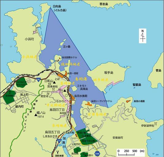
| Keywords: Map of Toba Port, Mie.jpg en This is a map of Toba port Mie Japan Dark blue is Toba port light blue is water sea river ponds and so on pink is urban area dark green is open space schools parks factories and so on light green is land orenge is major buildings brown is Japanese national routes and yellow is Mie prefectural roads ja õĖēķćŹń īķ│źńŠĮÕĖéŃü«ķ│źńŠĮµĖ»Ńü«Õ ░Õø│Ń éµ┐āŃüäķ ÆĶē▓Ńü«ķā©ÕłåŃüīķ│źńŠĮµĖ»Ń üµĘĪŃüäķ ÆĶē▓Ńüīµ░┤Õ¤¤’╝łķ│źńŠĮµĖ»ŃéÆķÖżŃüŵĄĘÕ¤¤Ń üµ▓│ÕĘ Ń üµ▒ĀŃü¬Ńü®’╝ēŃ üµĪāĶē▓ŃüīÕĖéĶĪŚÕ ░Ń üµ┐āŃüäńĘæĶē▓Ńüīń®║ŃüŹÕ ░’╝łÕŁ”µĀĪŃ üÕģ¼Õ ÆŃ üÕĘźÕĀ┤ńö©Õ ░Ńü¬Ńü®’╝ēŃ üµĘĪŃüäńĘæĶē▓ŃüīķÖĖÕ ░Ń üµ®ÖĶē▓ŃüīõĖ╗Ķ”üÕ╗║ķ Āńē®Ń üĶīČĶē▓ŃüīÕøĮķüōŃ üķ╗äĶē▓ŃüīõĖēķćŹń īķüōŃü¦ŃüéŃéŗŃ é own Miyuki Meinaka 2011-03-03 File Toba Port Map png 34 29 4 N 136 51 0 E Cc-zero Port of Toba Maps in Japanese Created with Adobe Illustrator | ||||