MAKE A MEME
View Large Image

| View Original: | Modern_Asia_(1796).tif (1024x1287) | |||
| Download: | Original | Medium | Small | Thumb |
| Courtesy of: | commons.wikimedia.org | More Like This | ||
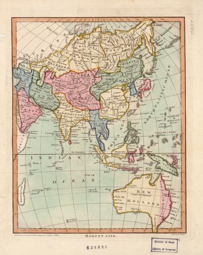
| Keywords: Modern Asia (1796).tif en John Wilkes was a London publisher best known for his Encyclopaedia Londinensis; or universal dictionary of arts sciences and literature 1801-28 Wilkes frequently worked with Samuel John Neele the engraver of this hand-colored map of modern Asia The map reflects late 18th-century European geographic conceptions and terminology India is referred to as Hindoostan while much of the interior is shown as comprised of Western Tartary and Chinese Tartary Tartary was a designation applied by Europeans to those parts of Asia inhabited by nomadic Turkic and Mongol peoples This map shows Tartary as stretching from the Caspian Sea to the Pacific Ocean fa ŲŲØīŲŲ ÂŦØĒØģÛØ§Û ŲŲÛŲÂŧ اÛŲ ŲŲØīŲ اطŲاØا؊ ØąØ§ÛØŽ Ų ØŠØĩŲØąØ§ØŠ ØŽØšØąØ§ŲÛ ØŊاŲاŲ Ø§ØąŲŲūاÛÛ Ø§ŲاØŪØą ØģØŊŲŲ ŲØŽØŊŲŲ Ų ÛŲاØŊÛ ØąØ§ ŲØīاŲ Ų Û ØŊŲØŊ ar ŲاŲ ØŽŲŲ ŲŲŲŲØģ ŲاØīØąØ§ ŲŲØŊŲŲا ŲاØīØŠŲØą ŲØđŲ ŲŲ Ų ŲØģŲØđØĐ ŲŲŲØŊŲŲŲŲØģŲØģØ ØĢŲ اŲŲاŲ ŲØģ ØĢŲØđاŲŲ Ų ŲŲŲŲŲŲ ŲاŲØđŲŲŲ ŲاŲØĢØŊØĻ ŲĄŲĻŲ ŲĄ-ŲĒŲĻ ØđŲ Ų ŲŲŲŲØģ ØŊاØĶŲ ا Ų Øđ ØģاŲ ŲŲŲ ØŽŲŲ ŲŲŲ ŲŲŲ ŲŲاØī ŲØ°Ų اŲØŪØąŲØ·ØĐ Ø§ŲŲ ŲŲŲØĐ ØĻاŲŲØŊ ŲØĒØģŲا اŲØØŊŲØŦØĐ ØŠØđŲØģ اŲØŪØąŲØ·ØĐ Ø§ŲŲ ŲاŲŲŲ اŲØŽØšØąØ§ŲŲØĐ ŲاŲŲ ØĩØ·ŲØا؊ ØĻØĢŲØąŲØĻاŲŲ ØĢŲاØŪØą اŲŲØąŲ اŲØŦاŲ Ų ØđØīØą ŲØīØ§Øą ØĨŲŲ اŲŲŲØŊ ØĻŲŲØŊŲØģ؊اŲ ØĻŲŲŲ ا ŲØđØąØķ اŲŲØŦŲØą Ų Ų اŲØŊاØŪŲ ŲØĢŲŲ Ų ØĪŲŲ Ų Ų ØŠØ§ØąØŠØ§ØąŲ اŲØšØąØĻŲØĐ Ų ØŠØ§ØąØŠØ§ØąŲ اŲØĩŲŲŲØĐ ØŠØ§ØąØŠØ§ØąŲ ŲŲ اŲØŠØģŲ ŲØĐ Ø§ŲØŠŲ ØĢØ·ŲŲŲا اŲØĢŲØąØĻŲŲŲ ØđŲŲ ØŠŲŲ اŲŲ ŲاطŲ Ų Ų ØĒØģŲا اŲØŠŲ ŲØģŲŲŲا ØīØđŲØĻ اŲŲ ŲØšŲŲŲØĐ ŲاŲØŠØąŲŲØĐ ØŠØĻŲŲ ŲØ°Ų اŲØŪØąŲØ·ØĐ ØŠØ§ØąØŠØ§ØąŲ Ų Ų ØŠØŊØĐ Ų Ų ØĻØØą ŲØēŲŲŲ ØĨŲŲ اŲŲ ØŲØ· اŲŲاØŊØĶ es John Wilkes fue un editor de Londres conocido por su Enciclopaedia Londinensis o diccionario universal de las artes las ciencias y la literatura 1801-28 Wilkes solÃa trabajar con John Samuel Neele el grabador de este mapa pintado a mano de Asia moderna El mapa refleja la terminologÃa yconcepciones geogrÃĄficas europeas de finales del siglo XVIII Se hace referencia a la India como Hindoostan mientras que una gran parte del interior se muestra como compuesta de Tartaria Occidental y Tartaria China Tartaria fue una denominaciÃģn que aplicaron los europeos a las partes de Asia habitadas por los pueblos nÃģmades turcos y mongoles Este mapa muestra la Tartaria que se extiende desde el Mar Caspio hasta el OcÃĐano PacÃfico fr John Wilkes ÃĐtait un ÃĐditeur de Londres surtout connu pour son Encyclopaedia Londinensis ou dictionnaire universel des arts des sciences et de la littÃĐrature 1801-1828 Wilkes travaillait souvent avec Samuel John Neele le graveur de cette cette carte coloriÃĐe à la main de l'Asie moderne La carte reflÃĻteles conceptions et la terminologie gÃĐographiques europÃĐennes de la fin du 18ÃĻme siÃĻcle L'Inde est appelÃĐe Hindoustan tandis que la plus grande partie du continent asiatique est prÃĐsentÃĐe comme constituÃĐe de la Tartarie Occidentale et de la Tartarie Chinoise Tartarie ÃĐtait le nom donnÃĐ par les EuropÃĐens à ces rÃĐgions d'Asie habitÃĐes par des populations nomades turciques et mongoles Sur cette carte la Tartarie s'ÃĐtire de la mer Caspienne jusqu'à l'ocÃĐan Pacifique pt John Wilkes foi um editor em Londres conhecido pela sua EnciclopÃĐdia Londinensis; ou dicionÃĄrio universal de artes ciÊncias e literatura 1801-28 Wilkes trabalhou muitas vezes com John Samuel Neele o gravador deste mapa colorido a mÃĢo da Ãsia moderna O mapa reflete final do 18 th- conceitos geogrÃĄficos e terminologias do final do sÃĐculo Europeu A Ãndia ÃĐ referida como Hindoostan enquanto grande parte do interior ÃĐ mostrado como composto de Western Tartary e Chinese Tartary Tartary foi uma designaçÃĢo empregada pelos Europeus para as partes da Ãsia habitadas por povos nÃģmades Turcos e MongÃģis Este mapa mostra Tartary como uma faixa que se extende do mar CÃĄspio atÃĐ o Oceano PacÃfico ru ÐÐķÐūÐ― ÐĢÐļÐŧКŅ ÐąŅÐŧ ÐŧÐūÐ―ÐīÐūÐ―ŅКÐļО ÐļзÐīаŅаÐŧÐĩО Ð―Ð°ÐļÐąÐūÐŧÐĩÐĩ ÐļзÐēÐĩŅŅÐ―ŅО ŅÐēÐūÐĩÐđ Ņ Ð°ÐąÐūŅÐūÐđ Encyclopaedia Londinensis ÐļÐŧÐļ ŅÐ―ÐļÐēÐĩŅ ŅаÐŧŅÐ―ŅО ŅÐŧÐūÐēаŅ ÐĩО ÐļŅКŅŅŅŅÐē Ð―Ð°ŅК Ðļ ÐŧÐļŅÐĩŅ аŅŅŅ Ņ 1801-1828 ÐģÐģ ÐĢÐļÐŧКŅ ŅаŅŅÐū Ņ Ð°ÐąÐūŅаÐŧ Ņ ÐĄÐ°ÐžŅŅÐŧÐĩО ÐÐķÐūÐ―ÐūО Ð ÐļÐŧÐūО ŅÐūзÐīаŅÐĩÐŧÐĩО ÐīÐ°Ð―Ð―ÐūÐđ КаŅ ŅŅ-ÐģŅ аÐēŅŅ Ņ Ņ ŅŅÐ―ÐūÐđ Ņ аŅКŅ аŅКÐļ ÐŋÐūÐī Ð―Ð°Ð·ÐēÐ°Ð―ÐļÐĩО ŅÐūÐēŅ ÐĩОÐĩÐ―Ð―Ð°Ņ ÐзÐļŅ ÐаŅ Ņа ÐūŅŅ аÐķаÐĩŅ ÐĩÐēŅ ÐūÐŋÐĩÐđŅКÐļÐĩ ÐģÐĩÐūÐģŅ аŅÐļŅÐĩŅКÐļÐĩ КÐūÐ―ŅÐĩÐŋŅÐļÐļ Ðļ ŅÐĩŅ ОÐļÐ―ÐūÐŧÐūÐģÐļŅ КÐūÐ―Ņа XVIII ÐēÐĩКа ÐÐ―ÐīÐļŅ Ð―Ð°Ð·ÐēÐ°Ð―Ð° ÐĨÐļÐ―ÐīŅŅŅÐ°Ð―ÐūО а ÐąÐūÐŧŅŅаŅ ŅаŅŅŅ ÐēÐ―ŅŅŅ ÐĩÐ―Ð―ÐĩÐđ ŅÐĩŅ Ņ ÐļŅÐūŅ ÐļÐļ ÐŋŅ ÐĩÐīŅŅаÐēÐŧÐĩÐ―Ð° КаК ÐаÐŋаÐīÐ―Ð°Ņ ÐĒаŅ ŅаŅ ÐļŅ Ðļ ÐÐļŅаÐđŅКаŅ ÐĒаŅ ŅаŅ ÐļŅ ÐĒаŅ ŅаŅ ÐļÐĩÐđ ÐĩÐēŅ ÐūÐŋÐĩÐđŅŅ Ð―Ð°Ð·ŅÐēаÐŧÐļ ŅÐĩ ŅаŅŅÐļ ÐзÐļÐļ КÐūŅÐūŅ ŅÐĩ Ð―Ð°ŅÐĩÐŧŅÐŧÐļ КÐūŅÐĩÐēŅÐĩ ŅŅŅ КŅКÐļÐĩ Ðļ ОÐūÐ―ÐģÐūÐŧŅŅКÐļÐĩ Ð―Ð°Ņ ÐūÐīŅ Ра ŅŅÐūÐđ КаŅ ŅÐĩ ÐĒаŅ ŅÐĩŅ ÐļŅ ÐļзÐūÐąŅ аÐķÐĩÐ―Ð° ÐŋŅ ÐūŅŅÐļŅ аŅŅÐĩÐđŅŅ ÐūŅ ÐаŅÐŋÐļÐđŅКÐūÐģÐū ОÐūŅ Ņ ÐīÐū ÐĒÐļŅ ÐūÐģÐū ÐūКÐĩÐ°Ð―Ð° 1 hand colored engraved map; 24 x 19 centimeters Scale 1 60 000 000 Institution Library of Congress PD-old-100 1796 maps Maps in English Old maps of Asia Maps of the Persian Gulf Old maps of Australia Images from the World Digital Library Engraved maps Images from the Library of Congress | ||||