MAKE A MEME
View Large Image

| View Original: | NiederfrûÊnkisches-NiederlûÊndisches Sprachgebiet.png (845x1071) | |||
| Download: | Original | Medium | Small | Thumb |
| Courtesy of: | commons.wikimedia.org | More Like This | ||
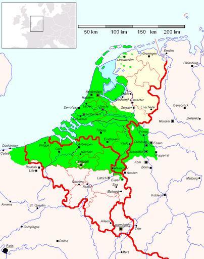
| Keywords: NiederfrûÊnkisches-NiederlûÊndisches Sprachgebiet.png Karte mit dem Verbreitungsgebiet des RheinfrûÊnkischen mit das Gebiet der NiedersûÊchsischen Mundarten den die NiederlûÊndische Hochsprache verwenden <br/> de Kategorie Dialekt <br> Map with the position of Low Frankish shown including the Low Saxon area that uses the Dutch standard language as the language of culture <br> NiederfrûÊnkisches_Sprachgebiet PNG 2009-07-20 10 35 UTC NiederfrûÊnkisches_Sprachgebiet PNG Et Mikkel wikipedia de <br/> Mikkel 17 49 9 MûÊr 2008 CET derivative work Bataaf <span class signature-talk >talk</span> Bataaf Bataaf Low Franconian svg NiederfrûÊnkisches_Sprachgebiet PNG original upload log This image is a derivative work of the following images File NiederfrûÊnkisches_Sprachgebiet PNG licensed with PD-user 2008-12-20T18 18 44Z Spazzo 845x1071 63173 Bytes <nowiki>edited by Spazzo some positions of cities corrected Et Mikkel </nowiki> 2008-12-20T08 44 11Z Spazzo 845x1071 63350 Bytes <nowiki> </nowiki> 2008-03-16T16 19 35Z Et Mikkel 845x1071 73101 Bytes <nowiki>Auf Ameland wird heute auch eine niederfrûÊnkische Variante gesprochen</nowiki> 2008-03-14T00 10 41Z Et Mikkel 845x1071 73058 Bytes <nowiki> û bergangsgebiete weg da die betroffenen Regionen von der Abstammung Niederfranken waren und nur sprachliche Eigenheiten der Mitteldeutschen aufgewiesen haben eigene Arbeit </nowiki> 2008-03-09T21 03 52Z Et Mikkel 845x1071 75102 Bytes <nowiki> Karte mit dem Verbreitungsgebiet des de NiederfrûÊnkischen de Kategorie Dialekt Transferred from http //de wikipedia org de wikipedia Original text Nach Franz Petri</nowiki> Uploaded with derivativeFX Dutch dialects Germanic languages Linguistic maps of Belgium Linguistic maps of France Linguistic maps of Germany Linguistic maps of the Netherlands Linguistic maps of the Dutch language Maps in German Sociolinguistics | ||||