MAKE A MEME
View Large Image

| View Original: | Regnes d'Anglaterra l'any 600.png (651x897) | |||
| Download: | Original | Medium | Small | Thumb |
| Courtesy of: | commons.wikimedia.org | More Like This | ||
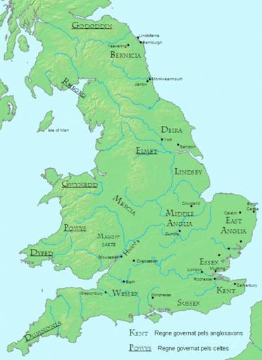
| Keywords: Regnes d'Anglaterra l'any 600.png Map of England and Wales showing Anglo-Saxon and Celtic kingdoms as of c 600 Redrawn from a map in James Campbell The Anglo-Saxons Penguin Books 1991 English_kingdoms_600 png 2011-12-30 19 44 UTC English_kingdoms_600 png English_kingdoms_600 gif Original uploader was Mike Christie at http //en wikipedia org en wikipedia derivative work Jappalang <span class signature-talk >talk</span> derivative work Arnaugir <span class signature-talk >talk</span> translated to Catalan Arnaugir English_kingdoms_600 png PD-user-w Original upload log This image is a derivative work of the following images File English_kingdoms_600 png licensed with PD-user-w 2009-04-03T05 02 08Z Jappalang 651x897 260809 Bytes <nowiki> Map of England and Wales showing Anglo-Saxon and Celtic kingdoms as of c 600 Redrawn from a map in James Campbell The Anglo-Saxons Penguin Books 1991 File English_king</nowiki> Uploaded with derivativeFX Maps of Anglo-Saxon England | ||||