MAKE A MEME
View Large Image

| View Original: | Regnum Sclavorum 754 AD.PNG (660x539) | |||
| Download: | Original | Medium | Small | Thumb |
| Courtesy of: | commons.wikimedia.org | More Like This | ||
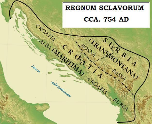
| Keywords: Regnum Sclavorum 754 AD.PNG en Map of fictituous Slavic kingdom of king Svetopelek in the Western Balkan as it has been described in Chronicle of Priest of Dioclea Artificial personality of Svetopelek should probably be seen as a king in the 8th century AD Yugoslavia_topographic_base_map svg; Sources for creation this map are A Texts 1 http //www montenegrina net/pages/pages1/istorija/duklja/ljetopis_pop_dukljanina_latinicna_redakcija htm Montenegrian translation of Chronicle of Priest of Dioclea; 2 Ĺ išić Ferdo 1990 Povijest Hrvata u vrijeme narodnih vladara Zagreb Nakladni zavod matice hrvatske Pages 456-457; 3 Stephenson Paul 2000 Byzantium's Balkan Frontier a Political Study of the Northern Balkans 900-1204 UK Cambridge University Press Pages 118-119 B Several maps of medieval Western Balkan were used for borders od fictituous kingdom 1 Voje Ignacij 1994 Nemirni Balkan Ljubljana DZS Page 82 “ map Dukljanska drĹľava v 11 stoletju for borders of Rascia Bosnia Zachlumia Travunia and Dioclea page 104 for medieval Rascia “ map Razvoj srednjeveške srbske drĹľave po dinastijo Nemanjićev 2 Kaniški T Regan K ur 2003 Hrvatski povijesni atlas Zagreb Leksikografski zavod Miroslav KrleĹľa Page 119 for Bosna Croatia and Rascia “ map 66 Hrvatska u drugoj polovici IX st 3 Sindik Ilija Map- Srbska drĹľava sredi X stoletja for borders between Rascia Bosnia Zachlumia Travunia and Dioclea Supplement to Babić Anto ur 1953 Zgodovina narodov Jugoslavije Prva knjiga do zaÄŤetka XXVI Stoletja Ljubljana DZS 2010-09-12 18 47 UTC Yugoslavia_topographic_base_map svg Future Perfect at Sunrise derivative work Bostjan46 <span class signature-talk >talk</span> Plain map was used for creation of historical map Bostjan46 Yugoslavia_topographic_base_map svg Maps of the history of Croatia in the Middle Ages Maps of the history of Dalmatia Maps of the history of Montenegro in the Middle Ages Maps of the history of Serbia in the Early Middle Ages Maps of the history of Bosnia and Herzegovina in the Middle Ages Maps of the history of Republika Srpska | ||||