MAKE A MEME
View Large Image

| View Original: | The_Quarterly_journal_of_the_Geological_Society_of_London_(13204915043).jpg (1196x2076) | |||
| Download: | Original | Medium | Small | Thumb |
| Courtesy of: | commons.wikimedia.org | More Like This | ||
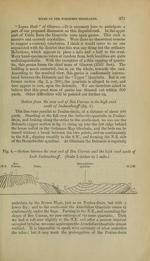
| Keywords: The Quarterly journal of the Geological Society of London (13204915043).jpg EOCKS OE THE NOETHEEN HIGHLANDS <br> 371 <br> Logan Rock of Glasven It is necessary here to anticipate a <br> part of our proposed discussion on this disputed rock In the upper <br> part of Calda Burn the Quartzite rests upon gneiss This rock is <br> massive and coarsely crystalline Were there no theoretical reasons <br> to suggest a contrary conclusion I think it would occur to no one <br> acquainted with the district that this was any thing but the ordinary <br> Hebridean which appears in place a mile and a half to the west <br> Many hand-specimens taken at random from both localities are quite <br> undistinguishable With the exception of a thin capping of quartz- <br> ite this gneiss forms the chief mass of Glasven 2541 feet The <br> bedding is much contorted but is on the whole towards the east <br> According to the received view this gneiss is conformably interca- <br> lated between the Dolomite and the Upper Quartzite But in our <br> former section fig 2 p 368 the quartzite is alleged to rest and <br> does appear to rest upon the dolomite We are therefore asked to <br> believe that this great mass of gneiss has thinned out within 500 <br> yards Other difficulties will be pointed out further on <br> Section from the west end of Ben Uarran to the high road <br> south of Inchnadamff fig 4 <br> This line runs parallel to Poulan-drein at a distance of about 400 <br> yards Standing at the fall over the /SaZ r ZZa-quartzite in Poulan- <br> drein and looking along the strike to the south-east we can see the <br> Dolomite upper section in fig 3 rising up into the low ridge behind <br> the house called in the Ordnance Map Glenbain and the beds can be <br> traced without a break between the two points and on continuously <br> to the S E dipping steadily to the S W and forming the N E side <br> of the Stronchrubie syncline At Glenbain the Dolomite is regularly <br> Fig 4 Section betiveen the west end of Ben Uarran and the high road south of <br> Loch Lnchnadamff Scale 3 inches to 1 mile <br> Ben <br> N E Uarran <br> Talus <br> Stronchrubie <br> syncline <br> W S W <br> underlain by the Brown Flags just as on Poulan-drein but with a <br> lower dip ; and to the south-east the Annelidian Quartzite comes in <br> conformably under the flags Turning to the N E and ascending the <br> slopes of Ben Uarran we pass outcrops of the same quartzite Then <br> we find it rollover slightly to the N E and after a narrow interval <br> occupied by talus we come again upon the Annelidian Quartzite almost <br> vertical It is impossible to speak with certainty of what underlies <br> the talus ; but it may mask the prolongation of the Poulan-drein 36928978 113681 51125 Page 371 Text 39 http //www biodiversitylibrary org/page/36928978 1883 Geological Society of London Biodiversity Heritage Library The Quarterly journal of the Geological Society of London v 39 1883 Geology Periodicals Smithsonian Libraries bhl page 36928978 dc identifier http //biodiversitylibrary org/page/36928978 smithsonian libraries Information field Flickr posted date ISOdate 2014-03-16 Check categories 2015 August 26 CC-BY-2 0 BioDivLibrary https //flickr com/photos/61021753 N02/13204915043 2015-08-26 12 51 39 cc-by-2 0 PD-old-70-1923 The Quarterly journal of the Geological Society of London 1883 Photos uploaded from Flickr by FĂŚ using a script | ||||