MAKE A MEME
View Large Image

| View Original: | UN_Partition_Plan_For_Palestine_1947.png (627x1147) | |||
| Download: | Original | Medium | Small | Thumb |
| Courtesy of: | commons.wikimedia.org | More Like This | ||
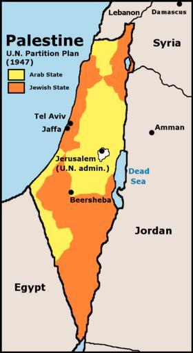
| Keywords: UN Partition Plan For Palestine 1947.png UN 1947 partition plan for Palestine Crop and edit of http //www lib utexas edu/maps/historical/israel_hist_1973 jpg Scan from Issues in the Middle East Atlas U S Central Intelligence Agency 1973 1973 U S Central Intelligence Agency According to lib utexas edu http //www lib utexas edu/maps/middle_east html here and http //www lib utexas edu/maps/historical/history_middle_east html here the map is produced by the U S Central Intelligence Agency unless otherwise indicated There is no such mark with this map so it is presumed the map is PD-US-GOV UN Partition Plan For Palestine 1947 svg <br/> UN Partition Plan For Palestine 1947-cs png norsk tekst <br> dansk tekst <br> PD-USGov Delete all revisions of this file cur 19 00 27 May 2006 DJMatus23 Talk contribs block 627×1147 67 165 bytes Reverted to earlier revision del rev 19 58 16 May 2006 Javadane Talk contribs block 306×557 10 448 bytes Reverted to earlier revision del rev 19 57 16 May 2006 Javadane Talk contribs block 627×1147 67 165 bytes Reverted to earlier revision del rev 08 54 22 September 2005 Doviende Talk contribs block 627×1147 71 732 bytes added label for Jordan River del rev 08 45 22 September 2005 Doviende Talk contribs block 627×1147 67 165 bytes Map showing the 1947 UN partition plan for palestine inspired by User JamesDay's similar image but redone from the source with better fonts and non-fuzzy colors Copyright GFDL derivative work created by the uploader based on a portion of the publ del rev 12 45 2 October 2003 JamesDay Talk contribs block 306×557 10 448 bytes Map showing the 1947 UN partition plan for Palestine Maps of the United Nations Partition Plan for Palestine Maps of Israel | ||||