MAKE A MEME
View Large Image
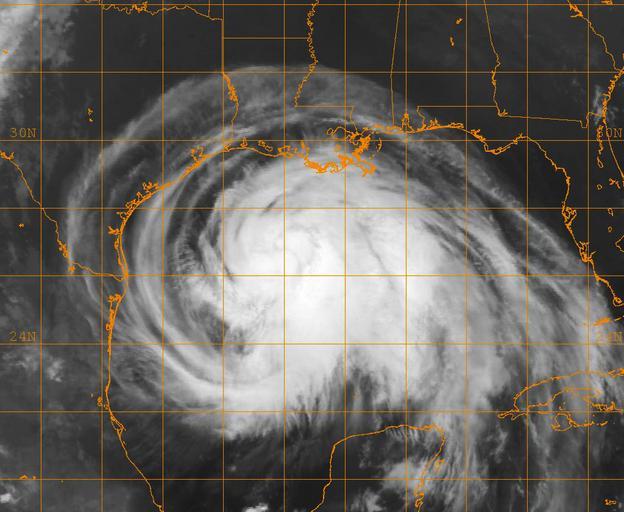
| View Original: | US_Navy_080912-N-0000X-001_A_GOES-12_infrared_satellite_image_provided_by_the_U.S._Naval_Research_Laboratory,_Monterey,_Calif.,_showing_the_status_of_Hurricane_Ike_at_approximately_4-15_a.m._EST_Friday,_Sept._12.jpg (1024x840) | |||
| Download: | Original | Medium | Small | Thumb |
| Courtesy of: | commons.wikimedia.org | More Like This | ||
| Keywords: US Navy 080912-N-0000X-001 A GOES-12 infrared satellite image provided by the U.S. Naval Research Laboratory, Monterey, Calif., showing the status of Hurricane Ike at approximately 4-15 a.m. EST Friday, Sept. 12.jpg en GULF OF MEXICO Sept 12 2008 A GOES-12 infrared satellite image provided by the U S Naval Research Laboratory Monterey Calif showing the status of Hurricane Ike at approximately 4 15 a m EST Friday Sept 12 Ike has maximum sustained winds of 105 mph and a forward movement of about 13 mph Ike is expected to strike near Galveston Texas as a major hurricane late Friday or early Saturday morning U S Navy photo Released 2008-09-12 080912-N-0000X-001 Navy http //www navy mil/view_image asp id 63834 U S Navy photo PD-USGov-Military-Navy Satellite pictures of the Gulf of Mexico Satellite pictures of Hurricane Ike GOES 12 pictures | ||||